Dayton Area Stays · A local cycling guide
Miami Valley Bike Trails & Suggested Rides

Six rides. River views. Trail-town discoveries.
And a comfortable place to come home to.
Choose a 30–40-mile ride starting in Xenia, Miamisburg, Beavercreek, Kettering, or Taylorsville MetroPark. Follow the Great Miami River or explore the Creekside, Ohio-to-Erie, and Iron Horse trail corridors. Find a home near your starting point, plan a few worthwhile stops, and make a weekend of the ride.
Why ride here
River views, small towns, and room to roam
Ride at your own pace
Paved, shared-use trail lets you build an out-and-back around your energy, your group, and your lunch plans.
Make the stops the point
Downtown Miamisburg, Franklin’s murals, Dayton’s riverfront, Tipp City, and Yellow Springs’ shops and cafés give the region’s trail rides a different personality. Explore Yellow Springs on the Little Miami Scenic Trail, part of the wider Miami Valley trail network.
Turn a ride into a getaway
Unpack once, choose a different trailhead each day, and leave time for dinner and a relaxed evening.
Use the regional trail guide ↗ for the full network. Some outlying sections are separate; check the map before planning a through-ride.
Five homes. Six rides. One map.
Trail geometry: Miami Valley Trails
Hover over a marker for its name. Select it for details. Drag to pan; use + / − to zoom.
Route details & nearby stays
Xenia to South Charleston
via Cedarville
Suggested ride: about 38 miles round trip
The bike path runs right next to Tandem-Trails Retreat for easy access.
Ride along it to Xenia Station, about 0.3 mile away.
Parking: Public parking at Xenia Station, 150 South Miami Avenue. Guests can leave the car at the home and ride to the station.
Village stops & open-country riding
Xenia Station → Ohio-to-Erie / Prairie Grass Trail → Cedarville → South Charleston → return
Follow the northeast trail from Xenia. Stop in Cedarville on the outward ride, continue to South Charleston, and return by the same route. This is the regional touring guide’s approximately 38-mile itinerary.
The ride starts at Xenia Station. Riding from the house adds the connection to and from the hub. Allow time for lunch and village street crossings.
Xenia to Yellow Springs
& the Little Miami Scenic Trail
30-mile ride plan · Turn around at 15 miles
The bike path runs right next to Tandem-Trails Retreat for easy access.
Ride along it to Xenia Station, about 0.3 mile away.
Parking: Public parking at Xenia Station, 150 South Miami Avenue. Guests can leave the car at the home and ride to the station.
Village browsing & a longer trail day
Xenia Station → Little Miami Scenic Trail north → Yellow Springs Station → continue toward Springfield → turn at 15 miles → return
Ride north from Xenia Station on the Little Miami Scenic Trail. Stop at Yellow Springs Station for a break, then continue north until your trip meter reaches 15 miles. Retrace the route for a 30-mile outing, leaving time to browse the village or stop for lunch on the return.
Shorter option: Turn around in Yellow Springs instead of extending north. The village is roughly 9–10 miles from Xenia Station; the shorter outing is approximately 18–20 miles round trip, depending on your stops.
Worth a stop: Yellow Springs Station and Hilda M. Rahn Park; downtown shops; Winds Cafe for a planned lunch. Downtown dining is a short detour from the trail.
Start the mileage at Xenia Station; the home connection and town detours add distance. Check current Little Miami trail alerts, particularly around Brush Row Road / Great Council Bridge. If a posted road detour does not suit your group, choose another ride.
Miamisburg to Dayton’s
Riverfront & Beyond
34-mile ride plan · Turn around at 17 miles
Start: Riverfront Park, about 0.2 mile from the home.
Ride or walk your bike to the park using sidewalks and marked crossings. Join the Great Miami River Trail at Riverfront Park, then head north toward Dayton.
Parking: Public lot at Riverfront Park, 3 North Miami Avenue. Start your trail mileage at the park.
River towns to the Dayton skyline
Riverfront Park → West Carrollton → Carillon area → RiverScape → continue north → return at 17 miles
Ride north on the Great Miami River Trail. Take a break around Carillon or RiverScape, then keep following the river north until your trip meter reaches 17 miles. Retrace the route for a 34-mile ride.
This extends the regional guide’s shorter Dayton–Miamisburg outing. The turnaround is set by distance; stops and detours add mileage. Check the map before riding.
Beavercreek to Xenia
& the Cedarville Countryside
36-mile ride plan · Turn around at 18 miles
Start: Creekside Reserve / bikeway, about 1.1 miles away.
Beavercreek Station is about 1.8 miles from the home.
Parking nearby: E.J. Nutter Park or another signed Creekside Trail lot. Transport bikes to the lot or use a suitable local-street connection.
A hub-to-countryside day
Creekside entry → east toward James Ranch → Xenia Station → Ohio-to-Erie Trail toward Cedarville → return at 18 miles
Use Xenia Station as your first substantial break before continuing northeast into the Prairie Grass corridor. Plan your second stop around Cedarville, then use your trip meter to cap the outward leg at 18 miles.
The return follows the same route. The trip from the home to the trail is separate; starting at a different parking lot changes where the 18-mile turnaround falls.
Kettering’s Iron Horse
& Creekside Connection
34-mile ride plan · Turn around at 17 miles
Nearest entry: Iron Horse Trail at Rahn Road, about 2.0 miles away.
Follow the signed route north toward Creekside.
Drive-to option: Use Iron Horse Park, 6161 Millshire Drive. Parking at the Rahn Road crossing is not confirmed.
Link the Iron Horse & Creekside corridors
Rahn Road entry → signed Iron Horse route north → Creekside junction → east toward Beavercreek / Xenia → return at 17 miles
Ride the signed Iron Horse corridor through Kettering and join Creekside eastbound. Pause at a suitable trail hub, then turn back once your outward distance reaches 17 miles.
Includes shared-road sections: Iron Horse includes shared streets and wide sidewalks, including sections around Hempstead Station Drive and Glengarry / Powhattan. This is for riders comfortable with those connections.
If parking at Iron Horse Park, begin the meter there and use the same 17-mile outward target. Do not treat the network’s published 19-mile total as one continuous separated trail.
Taylorsville to Tipp City,
Troy & Beyond
36-mile ride plan · Turn around at 18 miles
Nearest access area: Taylorsville MetroPark bike path, about 3.1 miles away.
Rip Rap Rd Park is about 3.8 miles away.
Parking: Designated Great Miami trail-access lot at 2000 U.S. 40. The nearest-path distance may differ from the drive to this lot.
History, parkland & river towns
Taylorsville trail access → Tadmor → Kyle Park / Tipp City → Troy corridor → return at 18 miles
Follow the Great Miami River Trail north. Pause at Tadmor and choose a town stop around Tipp City or Troy. Continue on the river corridor until 18 outward miles, then retrace the route for about 36 miles.
The exact turnaround may be beyond Troy depending on the starting lot and detours. Town-center meal stops can involve local streets and add distance.
Food · Landmarks · Trail-town discoveries
Worth a stop along the way
Choose a few stops that fit your ride. Town visits and meal detours add time and distance; check opening hours before setting out.
Xenia, Yellow Springs & the eastern trails
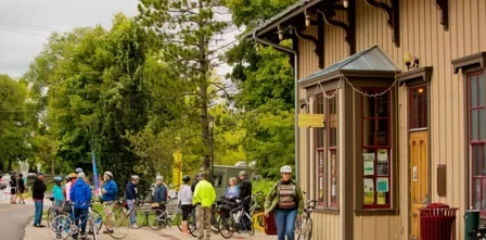
Yellow Springs Station & village browsing
The replica train station at 101 Dayton Street sits beside the trail in Hilda M. Rahn Park. It makes a useful pause with public restrooms and the Wheeling Gaunt sculpture nearby. Lock your bikes where permitted and explore downtown shops on foot.
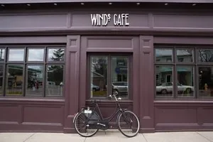
Winds Cafe in Yellow Springs
Plan a sit-down lunch at 215 Xenia Avenue if the timing suits your ride. The cafe lists lunch Tuesday–Saturday and is closed Sunday and Monday. Confirm the current menu, hours and reservation options before making it your meal stop; secure the bikes and walk through downtown.
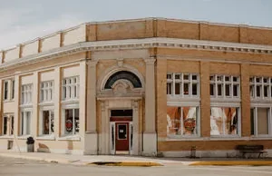
Cedarville & South Charleston
On the eastern Xenia ride, use Cedarville for a break before continuing toward South Charleston. The villages give the countryside ride a natural place for food and browsing. Choose your cafe in advance, check its hours, and allow for street crossings and the return journey.
Miamisburg & Franklin
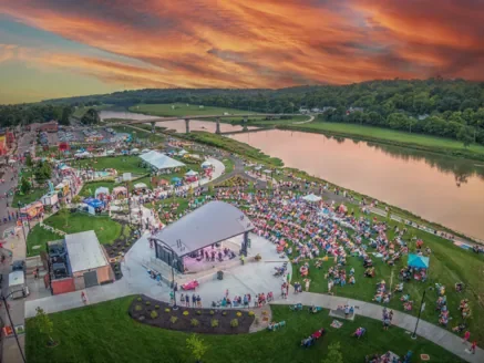
Riverfront Park & downtown Miamisburg
Pause by the river, then explore downtown shops and restaurants a short walk from the trail. Riverfront Park at 3 North Miami Avenue has listed public parking and bike racks. Downtown involves street crossings; lock the bikes and explore on foot when sidewalks are busy.
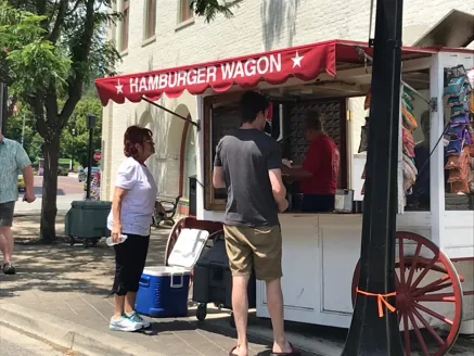
Hamburger Wagon at Market Square
Make a short downtown detour to Market Square and Main Street for this local burger stop. Finish your riding segment, secure the bikes, and leave time to browse the square. Check the menu and opening hours before planning lunch around it.
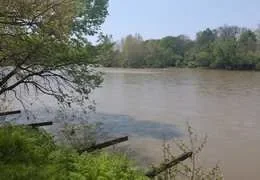
Crains Run Nature Park & Sunfish Lock
The wooded park offers a picnic break on the river trail south of Miamisburg. Pack food and water; the township lists a portable restroom at the south end, with seasonal availability. The restored 1829 canal lock is across the road near that end of the park—check traffic and walk bikes for the crossing if needed.
Route fit: These stops are south of Riverfront Park, separate from the northbound Dayton ride.
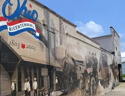
Franklin’s murals & Old Log Post Office
Explore Eric Henn’s murals around Main Street and the Old Log Post Office exterior. Leave the river corridor, secure the bikes where permitted, and view the murals on foot. Interior visits depend on opening schedules; downtown detours add mileage.
Route fit: Franklin is south of Miamisburg; choose it as a separate outing rather than adding it to the northbound Dayton plan.
Dayton & the northern river towns
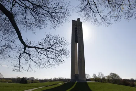
Carillon Historical Park & Carillon Brewing Co.
Turn a Dayton ride into a history outing at 1000 Carillon Boulevard. A full museum visit deserves its own block of time. Carillon Brewing Co. offers a meal nearby; Dayton History says museum admission is not required to dine there. Check current hours and bicycle parking; museum admission is separate.
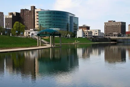
RiverScape MetroPark
Stop for gardens, river views and a downtown photo break. Drinking water, restrooms and trail access are listed, but seasonal availability and events can affect access. If starting here, check parking restrictions separately.
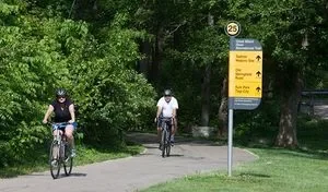
Taylorsville MetroPark & the Tadmor story
Pause for a snack and learn about Tadmor, a former village shaped by the river, canal, railroad and National Road. Use the park map for any side exploration. The paved bikeway and hiking paths have different uses; secure bikes before walking and follow posted trail rules.

Downtown Tipp City lunch stop
Choose a meal stop before riding, with options listed by Visit Tipp City including Sam and Ethel’s, Harrison’s and Coldwater Cafe. Downtown requires a detour from the trail. Check current hours, confirm your street connection, and lock the bikes for a stroll through the shopping district.
A little planning goes a long way
Before you ride
Check the trail that morning
River levels can close low sections, and a trail that has drained may still have mud or debris. Check both high-water conditions and posted construction detours before leaving.
Build in the return trip
Bring water, snacks, a helmet, a lock, and basic repair supplies. Confirm parking and opening hours. This is a shared-use trail: yield appropriately, announce passing, and slow down near people and crossings.
Suggested itineraries by Dayton Area Stays. Route and stop information checked October 28, 2026 using Miami Valley Trails, Miami Conservancy District, Miami Township, Dayton History, and the linked businesses. Times are estimates; access and hours can change.
Stay a little longer
Your next good weekend starts here
Choose your ride. Find your home. Leave room for the stops along the way.
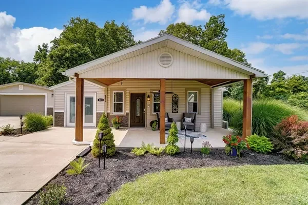
Tandem-Trails RetreatXenia
2 bedrooms · Sleeps 4
Bike path right beside the propertyAbout 0.3 mi to Xenia Station
Fire pit · BBQ grill
Full kitchen · Wi-Fi · Free on-site parking
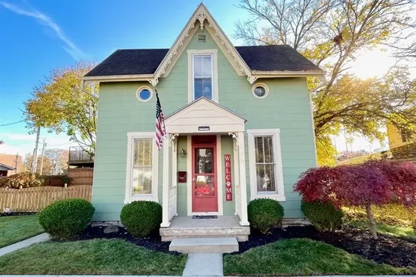
Cottage d’AmoreMiamisburg
3 bedrooms · Sleeps 6
About 0.2 mi to the bike pathRiverfront Park · Great Miami River Trail
Private patio · BBQ grill
Full kitchen · Wi-Fi · Free on-site parking

Meadow Run RetreatBeavercreek
3 bedrooms · Sleeps 6
About 1.1 mi to the bike pathCreekside Reserve · Creekside Trail
Private hot tub · Fire pit · Wooded yard
Full kitchen · Wi-Fi · Free on-site parking

Koi House of KetteringKettering
4 bedrooms · Sleeps 8
About 2.0 mi to the bike pathRahn Road · Iron Horse Trail
Arcade · Kids’ playroom · Private theater · Massage chair
Full kitchen · Wi-Fi · Free on-site parking

Deer Bluff LandingHuber Heights
4 bedrooms · Sleeps 10
About 3.1 mi to the bike pathTaylorsville MetroPark · Great Miami River Trail
Arcade · Air hockey · Private movie theater
Full kitchen · Wi-Fi · Free on-site parking
Trail-access distances are approximate one-way estimates. Review each home for amenities and booking details.